Location of Ezekiel's Temple
The location of the Temple is defined on the basis of Ezekiel's prophecy quite simply and if there were no annoying mistakes when translating the Bible into English, then perhaps English or American Bible researchers could have found this place in the past centuries.
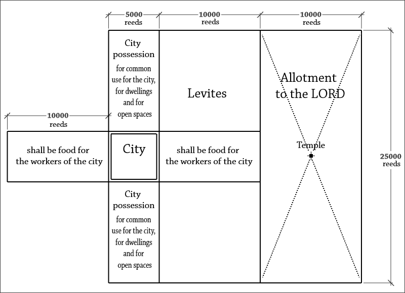
The size of one reed in Ezekiel's prophecy is 6 cubits, and the cubit is 48 cm, this standard value is known in Judaism. Thus, the length of 25,000 reeds is 72 km, and the length of 10,000 reeds is 28.8 km. Having the map of Israel, we can try to place the square of the holy allotment in the real borders of Israel, given that the eastern border of Israel, according to the prophecy of Ezekiel, passes through the Jordan and the Dead Sea, as the eastern border of today's state of Israel.
Important note: when you draw the rectangles measured in Ezekiel's prophecy, do not make the 2 mistakes that all the English-speaking commentators of Ezekiel's prophecy are doing:
– In the English translations of the Bible, the measurement of the sides of the rectangles of thethe holy allotment in cubits is erroneously indicated. In the Masoretic text of the Bible concerning these dimensions, there is no mention of any unit of measurement at all.But since measuring the length of 500 reeds in the prophecy, the unit of measure is indicated (reeds), then when measuring much longer lengths of sacred sites, the same unit of measurement was used.
– When the prophecy of Ezekiel says "toward the north, 25,000 in length, toward the west 10,000 in width," these directions of light indicate the direction of the movement of those who made these measurements at the time of measurement, and not the side of the rectangle that they measured. Do not rotate the rectangles of the holy allotment 90 degrees on the side.
In the Russian translation of the Bible, there is no such error with units of measurement, but this translation was made only in the 19th century, and this translation was not used in liturgical practice of the Russian Orthodox Church. Then came the 20th century, power in Russia was captured by godless Bolsheviks and the distribution of the Bible was brutally persecuted by the Soviet authorities and the KGB. Only in the 90s of the 20th century the Russian Synodal translation of the Bible became widespread in Russia, so in the late 90s we were able to determine the location of the future Temple. But on this our difficulties did not end: we did not have religious organizations supporting us, there was no Internet, no computers and accurate maps of Israel, to determine the exact coordinates of the future of the Third Temple.
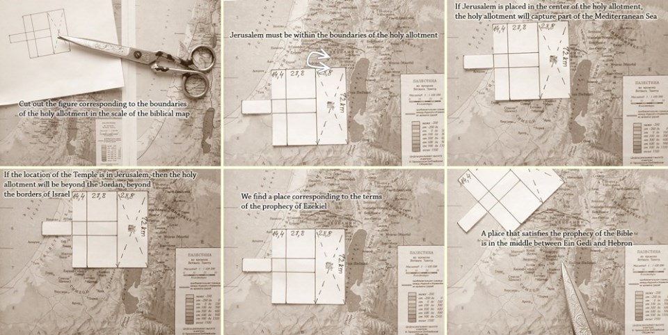
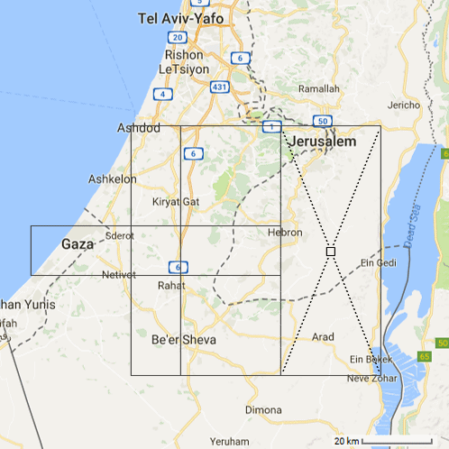
In accordance with the prophecy of Ezekiel, the location of the Third Temple is unambiguously and precisely defined as the geometric center of the rectangle of an allotment to the Lord, 28.8 km in length from the east to the west, and 72 km from north to south, at the same time, the historical part of the city of Jerusalem should be inside this allotment near its northern border, and this part of the land itself, in turn, is the eastern part of the larger an holy allotment, a square 72 km by 72 km, the eastern side of which should not cross the Jordan and should not extend into the Dead Sea, and the upper northwest corner of this square should not be In the Mediterranean Sea.
Of course, today we have modern programs to determine the location of the Third Temple with high accuracy. Anyone can independently verify the correct location of Ezekiel's Temple, using the Google Earth program.
How to determine the exact location of the Third Temple using the free Google Earth program >
Taking advantage of the opportunity provided by the development of modern technology, with the help of the Google Earth program, we were able to make sure that the square of the holy allotment can be located only in one place in the territory of Israel. At the same time, the possible deviation of the boundaries of the holy allotment in one direction or another can be no more than a hundred meters.
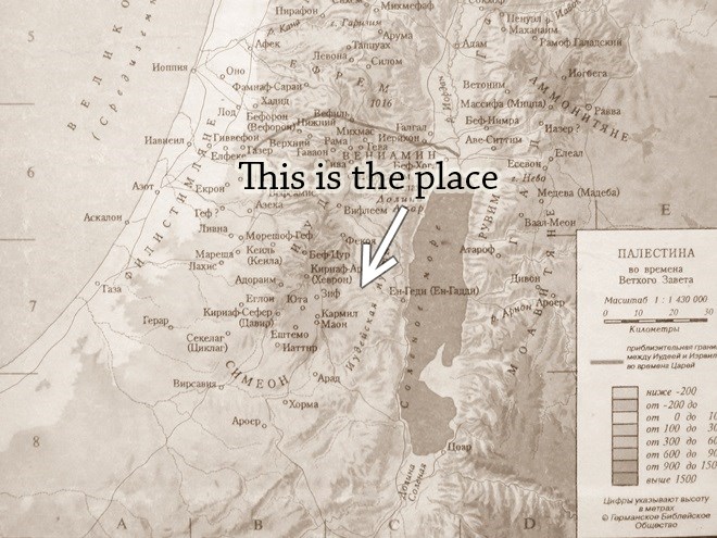
In accordance with the prophecy of Ezekiel, the Third Temple must be built in the Judean Desert, 30 km south of Jerusalem, between Ein Gedi and Hebron. Coordinates of the future of the Third Temple: 31°28'58"N 35°14'37"E .
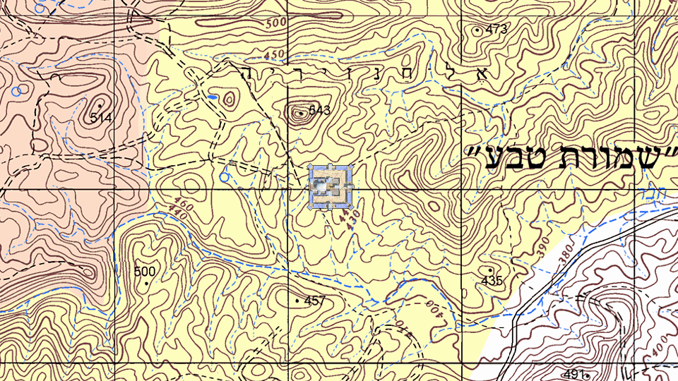
After making measurements in the Google Earth program, we saw that the center of intersection of the diagonals of a rectangular piece of land dedicated to the Lord turns out to be
– on the southern slope of a very high mountain, as was shown to Ezekiel in his vision;
– on the border of the watershed of two streams, Nahal Hever and Nahal Arugot, whose flow of water flows to the Dead Sea near Ein Gedi (The Source Of The Goatling) and Ein Eglaim (The Source Of The Two Heifer), in strict accordance with the prophecy of Ezekiel;
– in the place where the ruins of the ancient altar of Abraham are still visible, (Jehovah Jireh, that is, on the land of Moria - not to be confused with Mount Moriah in Jerusalem!);
– in the place where the underground streams of water pass from the Hebron Highlands, that is, from the right side of the Temple the flow of water will really flow, when the builders hollow out the foundation pit for the Third Temple.
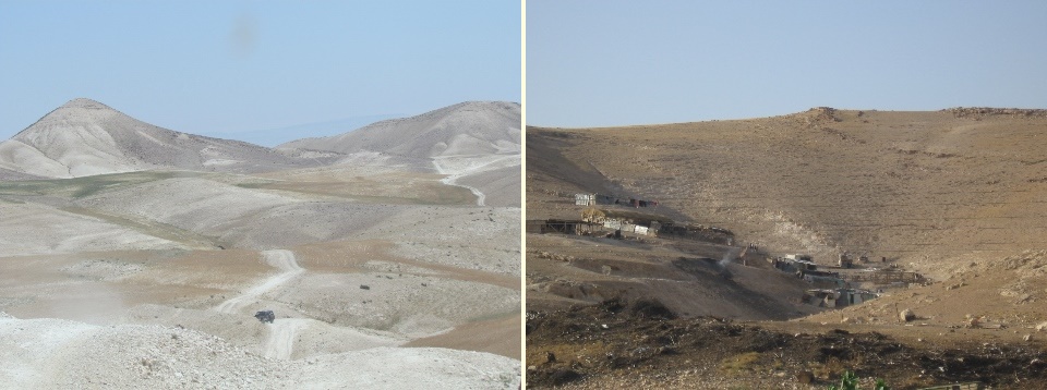
Both pictures show the same place. On the first picture to the left is a mountain 543 meters high, on this mountain stood the prophet Ezekiel in his vision. If the Temple were shown in this picture, we would see about one third of the temple complex, its south-western part, without the altar. On the second picture, on the contrary, a part of the southern slope of this mountain is shown, while the mountain itself on which the prophet Ezekiel stood is located beyond the border of the frame to the left, and the other mountain, which is opposite the Eastern gate of the Temple, is located beyond the border of the frame on the right. In the center of the second picture, apparently, we see the ruins of an ancient altar. If this is actually the ruins of an ancient altar, apparently, the altar of Abraham in the land of Moriah, the place was called Jehovah Jireh.
These pictures were found on the Internet.
Confirmation of our hypothesis that on this place the ruins of the ancient altar of Abraham are really located, can be a strong proof of the correctness of all our previous arguments.